How Far Does Tokyo Reach? From Chichijima to Japan’s Southernmost and Easternmost Edges
September 18, 2026
Tokyo looks compact when you think of it as a city.
On a map of the Pacific, it is anything but.
Chichijima lies about 1,000 kilometers south of Tokyo, and Hahajima lies about another 50 kilometers farther south. They are the two islands where Ogasawara Village’s civilian population is concentrated. But the Ogasawara Islands comprise more than 30 islands scattered across a huge area of the Pacific. (Ogasawara Village — Nature and Geography)
At the far edges of that map are two striking points: Okinotorishima at Japan’s official southernmost extent and Minamitorishima at its easternmost. Both are administered as part of Ogasawara Village, Tokyo. (Tokyo Metropolitan Government — Okinotorishima)
The Tokyo Islands You Can Visit — But Not Fly To
Chichijima is the administrative center of Ogasawara Village. Hahajima lies about 50 kilometers farther south.
Neither has commercial passenger air service.
The Ogasawara Maru is the only regularly scheduled passenger ship connecting the Ogasawara Islands with mainland Japan. The current vessel links Tokyo and Chichijima in about 24 hours. To reach Hahajima, passengers continue on the Hahajima Maru, which takes about two hours from Chichijima. (Ogasawara Kaiun — FAQ)
So Tokyo contains inhabited islands with hotels, homes and regular visitors — but no commercial passenger flights.
Farther out in the Pacific, however, there is an island with a runway that ordinary travelers cannot visit.
Beyond Chichijima and Hahajima
Ogasawara includes the Mukojima, Chichijima and Hahajima island groups, the Volcano Islands, and the isolated islands Nishinoshima, Minamitorishima and Okinotorishima. (Ogasawara Village — Nature and Geography)
Ioto once supported a civilian community. In 1944, most residents were forcibly evacuated as the war situation worsened. Even after Ogasawara returned to Japan in 1968, civilian resettlement on Ioto did not resume, and today the people stationed there are Self-Defense Forces personnel and related workers. (Ogasawara Village — Ioto)
These islands still belong to Tokyo, but they no longer resemble ordinary travel destinations.
Nishinoshima: A Tokyo Island That Changed Before Our Eyes
Nishinoshima lies about 130 kilometers west of Chichijima.
Volcanic activity beginning in 2013 created new land and greatly enlarged the island. Its recent activity has since declined: the Japan Meteorological Agency reported in September 2026 that no eruption had been observed since late 2023. Fumarolic activity, however, was still being observed, and an alert remained in force within roughly one kilometer of the summit crater. (Japan Meteorological Agency — Nishinoshima)
So Nishinoshima is not simply an old volcanic island.
Within living memory, the shape of this part of Tokyo changed dramatically.
Okinotorishima: Japan’s Southernmost Edge
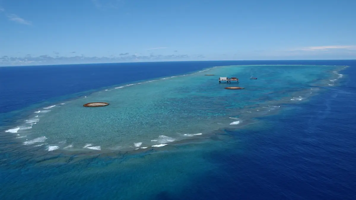
Much farther south lies Okinotorishima.
In Japan’s official geographic designation, it marks the country’s southernmost point. It is located at about 20°25′ north, roughly 1,700 kilometers south of central Tokyo and about 900 kilometers from Chichijima. Administratively, it belongs to Ogasawara Village. (Tokyo Metropolitan Government — Okinotorishima)
Okinotorishima is a large table reef. At high tide, only two small islets — Kitakojima and Higashikojima — remain above the sea surface. They are protected by extensive erosion-control structures. (Tokyo Metropolitan Government — Okinotorishima)
There is no town, hotel or regular passenger transport.
This is Tokyo not as a travel destination, but as the southern edge of Japan.
Minamitorishima: The Island with a Runway That Tourists Cannot Visit
Now move east.
Roughly 1,900 kilometers southeast of central Tokyo lies Minamitorishima, Japan’s easternmost island. It also belongs to Ogasawara Village. Official sources use slightly different Tokyo reference points and give distances of roughly 1,860 to 1,950 kilometers. (Tokyo Metropolitan Government — Minamitorishima)
The island is only about 1.5 square kilometers and has a runway as well as government facilities.
Japan Meteorological Agency staff rotate about once a month using Self-Defense Forces aircraft, with the flight taking roughly four hours. Food and supplies also arrive by aircraft. Yet there is no public transportation, visitor accommodation or general reception system, so ordinary members of the public cannot visit. (Japan Meteorological Agency — Minamitorishima FAQ)
That creates a remarkable reversal.
Chichijima has residents, accommodation and tourists — but no commercial passenger flights.
Minamitorishima has a runway and aircraft — but ordinary tourists cannot go there.
The island you can visit takes about 24 hours by ship.
The island you cannot visit can be reached by official aircraft in about four hours.
Why Is All of This Tokyo?
Ogasawara followed its own historical route into Tokyo administration.
In 1876, the Japanese government placed the islands under the Home Ministry and notified other countries of Japanese sovereignty. In 1880, administration was transferred to Tokyo-fu. (Tokyo Metropolitan Government — Ogasawara History)
The area expanded over time. The Volcano Islands came under Ogasawara administration in 1891, Minamitorishima in 1898 and Okinotorishima in 1931. (Tokyo Metropolitan Government — Ogasawara History)
Today’s vast Ogasawara administrative area was therefore not created in a single step. Islands scattered across the Pacific were incorporated into the same administrative framework over several decades.
One Village, Completely Different Worlds
“Ogasawara Village” sounds as though it should describe one compact community.
It does not.
The same municipality encompasses Chichijima and Hahajima, where people live ordinary daily lives; Nishinoshima, reshaped by recent volcanic activity; Ioto, where ordinary civilian resettlement has not resumed; Okinotorishima at Japan’s southern edge; and Minamitorishima at its eastern edge. (Ogasawara Village — Nature and Geography)
One Tokyo municipality therefore includes inhabited subtropical islands, active volcanic landscapes, coral reefs, remote government facilities and two of Japan’s geographical extremes.
Tokyo Is Not Just a City
The Izu Islands already make the idea of “Tokyo” larger than the metropolis on Honshu.
Ogasawara stretches that idea much farther.
From Takeshiba, travelers spend about 24 hours at sea and still arrive in Tokyo. From there, Tokyo’s administrative map continues hundreds of kilometers farther south and east.
At one edge is Okinotorishima.
At another is Minamitorishima.
And between them is perhaps the strangest contrast of all:
the Tokyo island where ordinary people live and tourists stay has no commercial airport service, while a Tokyo island with a runway is closed to ordinary travelers.
Tokyo is one of the world’s largest cities.
But geographically, that is only part of the story.